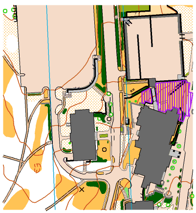
 Passable walls are in light gray (e.g., just west of the out of bounds is a V-shaped wall).
 The Mt Oread map is based on the ISSOM2005 standards for sprint maps. Refer to the sample map. Most college campuses have quite detailed maps and it was such a pleasure to find so many features mapped and exact. Of course, trees get removed and construction is always on-going, but overall the field checking went fast.
If you are new to the sprint mapping standards, one important difference is that thick black lines indicate barriers/uncrossable features. To ensure fairness, IOF rules state that features mapped uncrossable (walls, fences, cliffs) are also forbidden to cross. (e.g. see the black lines north of the out-of-bounds area).
 Passable walls are in light gray (e.g., just west of the out of bounds is a V-shaped wall).
Color: olive green are private areas, flower beds, etc. and you are not to enter or cross those area.
Color: dark green with tinge of black = impassable vegetation and forbidden to cross (e.g., there’s a long strip along the road down the middle of the sample map). The other lighter greens are the typical levels of runnability.
Buildings are in dark gray. The light gray in buildings are canopies and areas you can run through (e.g., look at the big parking lot in the west side and you will find a curved light gray line. You can run on top of the gray and below the gray).
Steps are represented in a general manner (e.g. several straight line steps are around the west-most building).
All pavement (roads, streets, sidewalks) are in a light brown (tan).
Keep out of the purple areas; they all have fencing are forbidden to enter – mostly construction sites.
In choosing route, read carefully looking for gaps, especially between the dark greens and solid black lines. (in the sample map, there is only one way to get from the left side of the map to the right).
All other colors you will be the familiar IOF standards.
Sprint rules forbid going into buildings. Using a door handle is a no-no.
Gene Wee (11/2006)